
Chapter 1 Locating Places on the Earth Notes & Summary
05/11/2024Chapter 3 Landforms and Life Notes & Summary
05/11/2024Introduction
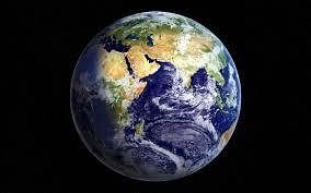
Imagine you’re an astronaut looking at Earth from space. What do you see? A beautiful, mostly blue sphere! This blue color comes from the vast amounts of water covering our planet. In fact, nearly three-fourths of Earth’s surface is covered in water, making it look like a “blue planet.”
Early astronauts were so fascinated by this view that they lovingly called Earth by this nickname. But water is not the only thing that makes Earth special. When you look closely, you will also see the color brown, which represents land. Although land covers only a little over one-fourth of the Earth’s surface, it plays a big role in our lives. The large bodies of water we see are called oceans, and the big stretches of land are known as continents.
Both oceans and continents are not just parts of a map; they shape the climate, affect all living things, and influence everything from the history of our planet to the cultures of people around the world. So, as we explore more about our planet, remember how these vast oceans and continents are connected to everything we do every day.
The Indian Navy’s Emblem and Its Significance
The emblem of the Indian Navy carries the motto “Sam noh Varunah” (pronounced ‘Sham no Varuqah’), which translates to “Be auspicious to us, O Varuna.” This phrase is a prayer to Varuna, a deity from Vedic tradition who is closely connected with the oceans, the sky, and water as a whole.
Try yourself:
What is the significance of the motto “Sam noh Varunah” in the emblem of the Indian Navy?
A.
It is a prayer to Lord Vishnu, the preserver of the universe.
B.
It is a tribute to the sun god, Surya, for his radiant energy.
C.
It is a request to the deity Varuna for protection and blessings related to the oceans.
D.
It is a dedication to the god of fire, Agni, for his purifying powers.
View Solution
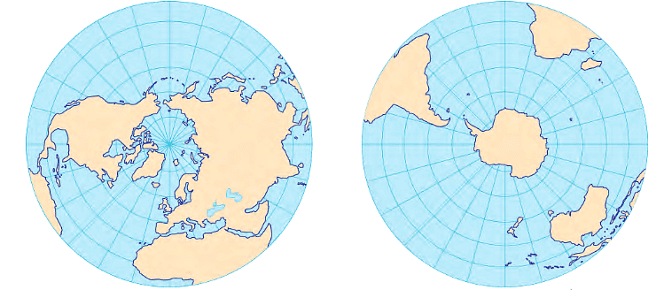
The Distribution of Water and Land on the Earth
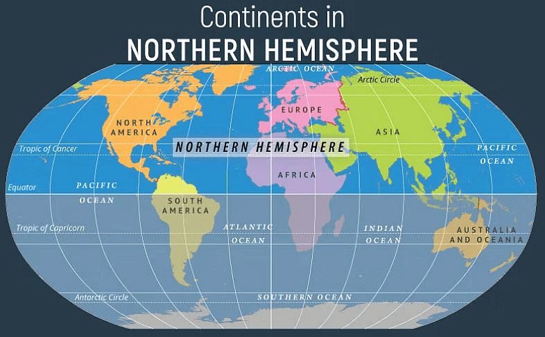
Can you notice which continent has the most land in the Northern Hemisphere?
Yes, the continent with the most land in the Northern Hemisphere is Asia.
Here’s why:
- Size: Asia is the largest continent on Earth, covering more land area than any other continent.
- Location: It stretches across a huge part of the Northern Hemisphere, from the Middle East to East Asia.
- Countries: Asia has many large countries, like China and Russia, which add to its vast land area.
So, if you look at a map, you’ll see that Asia takes up a big portion of the Northern Hemisphere!
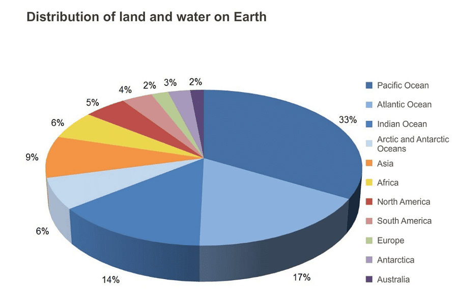 The Earth’s water and land are not evenly distributed between the Northern and Southern Hemispheres.
- Northern Hemisphere: This part of Earth has more land compared to water.
- Southern Hemisphere: This part has more water than land.
Understanding the Maps
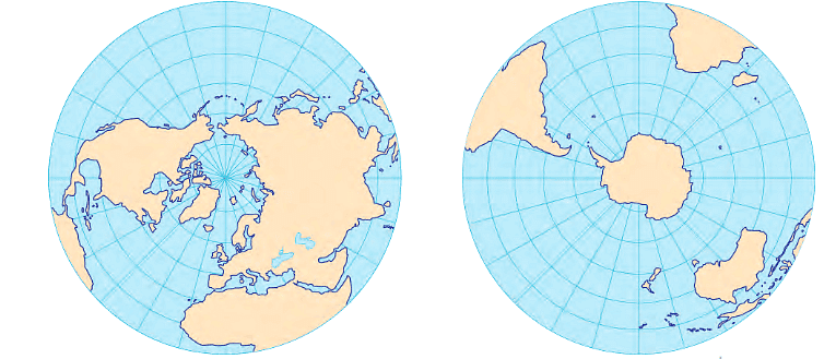
The maps above provide a view of the Earth from above the North Pole and the South Pole. In these maps, the blue areas represent the oceans, which also include smaller water bodies like seas, bays, and gulfs.
- Oceans: The vast bodies of saltwater that cover most of the Earth’s surface.
- Seas: Smaller extensions of the oceans, partially enclosed by land.
- Bays: Broad inlets of the sea where the land curves inward.
- Gulfs: Large areas of the sea partially enclosed by land, typically larger than bays.
Try yourself:
Which part of the Earth has more land compared to water?
A.
Northern Hemisphere
B.
Southern Hemisphere
C.
Both Hemispheres equally
D.
Cannot be determined
View Solution
Ocean Life
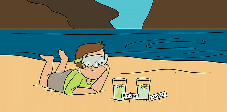
Did you ever wonder why seawater is salty? What makes it different from freshwater?
Yes, seawater is salty because it contains a lot of salt. Here’s why it’s different from freshwater:
- Salt in Seawater: Seawater has salt because rivers and rain wash salt from the land into the oceans. Over time, this salt builds up in the ocean.
- Freshwater: Freshwater, like in lakes and rivers, has much less salt. It’s mostly clean water because it hasn’t collected as much salt from the land.
So, the main difference is that seawater is salty due to all the salt that gets washed into the ocean, while freshwater has very little salt.
The oceans contain the majority of the Earth’s water, but this seawater is salty and cannot be used by most land animals, including humans.
In contrast, freshwater, which is safe for drinking and other uses, makes up only a small part of the Earth’s water.
Freshwater is found in glaciers, rivers, lakes, the atmosphere, and underground, where it is known as groundwater.
Oceans
 The Five Major Oceans
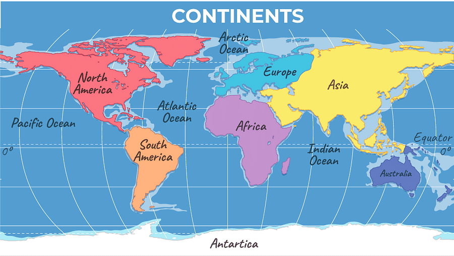
- On the world map, you can see five main oceans: The Pacific Ocean, Atlantic Ocean, Indian Ocean, Arctic Ocean, and Southern (or Antarctic) Ocean.
Even though we talk about these oceans as if they are separate, the lines that divide them on the map are just man-made. In reality, the oceans are connected, and water flows freely between them.
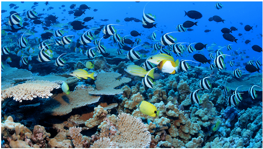
Marine Life and Biodiversity
The oceans are home to a wide variety of life. The plant life in the ocean, known as marine flora, includes tiny plants called algae and various seaweeds.
The animal life, known as marine fauna, includes thousands of species such as colorful fish, dolphins, whales, and many mysterious creatures that live in the deep sea.
Each part of the ocean, from the bright surface to the dark depths, is full of different life forms.
Size of the Oceans
The Pacific Ocean is the largest of the five oceans, followed by the Atlantic Ocean.
The Indian Ocean is the third largest, with the Southern Ocean being the fourth.
The smallest of the five oceans is the Arctic Ocean.
Understanding the Boundaries of the Indian Ocean
The Indian Ocean is bordered by Asia to the north, Africa to the west, and Australia to the east.
To the south, it is connected to the Southern Ocean.
- On either side of India, there are two important parts of the Indian Ocean:
The Arabian Sea lies to the west of India.
The Bay of Bengal is located to the east of India.
Oceans and disasters
Clouds and Rain
When looking at a picture of Earth, you might notice white shapes covering parts of the globe. These are large masses of clouds.
These clouds are responsible for bringing rain to the continents. For example, the monsoon rains in India, which are crucial for agriculture and life, originate in the ocean.
Ocean-Related Storms
Oceans can also create powerful storms.
These storms, like cyclones, bring heavy rain or strong winds and can cause significant damage, especially in coastal areas.
Tsunamis
A tsunami is another dangerous natural event that begins in the ocean. It is a massive and powerful wave, usually triggered by a strong earthquake or a volcanic eruption beneath the ocean.
Tsunamis can travel over long distances and flood coastal areas, leading to widespread destruction.
Tsunami of 2004 and Disaster Management
On 26 December 2004, a huge tsunami caused by an earthquake in Indonesia hit India and 13 other countries around the Indian Ocean. Over 200,000 people lost their lives. In India, the Andaman and Nicobar Islands, as well as the coasts of Tamil Nadu and Kerala, were badly affected.
Tsunamis like this are rare but very destructive. Fortunately, they can often be detected before they reach the coast. Many countries, including India, work together in an ‘early warning system’ to help protect lives and property. India also has a ‘National Disaster Management Authority’ to handle such disasters and minimize damage.
Continents
Understanding Continents: Different Ways to Count
How Many Continents Are There?
When looking at a map of the oceans, you can see the continents. But counting them isn’t straightforward, as the number can vary between four and seven, depending on how they are grouped.
Reasons for Different Counts
- North America and South America: Usually considered two separate continents, but they can also be seen as one single landmass.
- Europe and Asia: Although they form a single landmass, they are often seen as two continents due to their distinct historical and cultural developments. Geologists sometimes refer to them as one continent called ‘Eurasia.’
- Africa and Eurasia: These are typically regarded as two separate continents, but sometimes they are counted as one.
Summary of Different Counts
- Four Continents: Africa-Eurasia, America, Antarctica, Australia.
- Five Continents: Africa, America, Antarctica, Australia, Eurasia.
- Six Continents: Africa, Antarctica, Australia, Eurasia, North America, South America.
- Seven Continents: Africa, Antarctica, Asia, Australia, Europe, North America, South America (this is the most commonly used count).
The seven-continent model (Africa, Antarctica, Asia, Australia, Europe, North America, South America) is the most widely adopted and used worldwide.
Islands
If you’ve looked closely at the maps, you might have noticed that not all land is part of a continent. Some smaller land areas, completely surrounded by water, are called islands.
While continents are also surrounded by water, they are much larger and therefore not considered islands. There are hundreds of thousands of islands on Earth, and they vary greatly in size.
Exploring Islands and Antarctica
Greenland is the largest island in the world (you can find it on a globe or map). It’s so big that you would need to combine the areas of the 10 largest states in India to match its size.
India has over 1,300 small islands. The two main island groups are the Andaman and Nicobar Islands in the Bay of Bengal and the Lakshadweep Islands in the Arabian Sea.
Since 1981, India has been exploring Antarctica, a continent with an extremely cold climate. In 1983, India set up its first scientific base there, called ‘Dakshin Gangotri.’ Indian scientists have been researching the climate and environment in this remote region. The station where they live even has a library and a post office!