NCERT Solutions • Class 6 Social Science (Exploring Society) |
Chapter-wiseExploring Society India and Beyond Class 6 Solutionsand Class 6 Social Science SST Chapter 1 Locating Places on the Earth Question Answer NCERT Solutions are useful for focused study.
Locating Places on the Earth NCERT Class 6th SST Chapter 1 Question Answer
Locating Places on the Earth Class 6 Questions and Answers
The Big Questions (Page 7)
Question 1
|
(i) Distance: It is represented by the scale, which shows the ratio of a distance on the map to the actual distance on the ground.
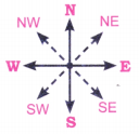
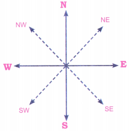
(ii) Direction: It is indicated by cardinal directions (north, east, south, and west) and intermediate directions (northeast, southeast, southwest, and northwest).
(iii) Symbols: They represent features like buildings, roads, and natural elements standardized in different countries.
Question 2
|
Question 3
|
Local Time: This is the time based on the position of the sun in a specific place. It changes with longitude because the Earth rotates, and different places see the sun at different times.
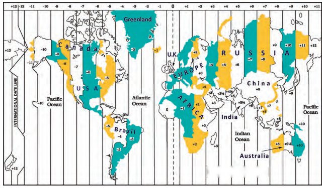
Standard Time: This is a uniform time used across a large area, like a country or region, to make it easier to coordinate activities. Each time zone has a standard time, which is usually set to match the local time at a central point within that zone.
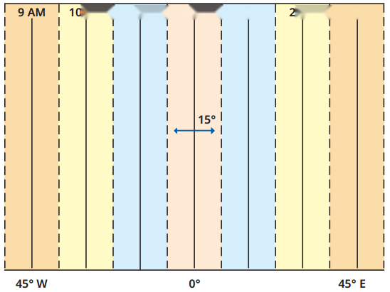
As you move east or west, the local time changes by 1 hour for every 15 degrees of longitude, because the Earth rotates 15 degrees each hour.
Let’s Explore
Question 1
|
Answer:
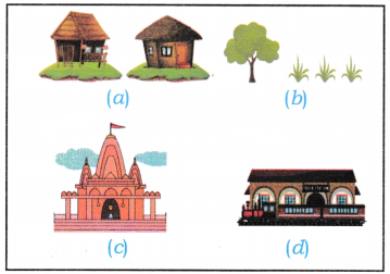
Water bodies, lake/pond and Stream.

Which is farther away from the railway station—the school, the Nagar Panchayat or the public garden?(Page 9)-
Answer:
Public garden.
Question 2
|

Question 3
|
Question 4
|
(ii) The museum is southeast of the bank.
Answer:
True
(iii) The railway station is northwest of the hospital.
Answer:
True
(iv) The lake is northwest of the apartment blocks. (Page 11)
Answer:
False
Question 5
|
Question 6
|
Question 7
|
Kolkata
Latitude: 22.5726°N
Longitude: 88.3639°E
3. Singapore
Latitude: 1.3521°N
Longitude: 103.8198°E
4. Paris.
Latitude: 48.8566°N
Longitude: 2.3522°E
Question 8
Solution:
Explanation: There is a difference of 30° between Porbandar (Gujarat) and Tinsukia (Assam). That is the local time difference is 4 min x 30° =120 minutes or 2 hours. Also the sunrises in Assam (Tinsukia) before it doesn’t Gujarat (Porbandar) as Assam is in North East of India and Gujarat in West of India.
|
The time both cities follow is the 1ST set at 82V2° E. SO while the standard time is the same the sun rise and sun set follows local time.
Calculation:
Tinsukia is 30° East of Porbandar
Since 1 ° = 4 minutes
30° = 4 minutes × 30 = 120 min.
= 120 minutes ÷ 6Q = 2 hours.
The time difference in local time is of 2 hours.
Question 9
|
Source-Based Questions (See passage on page 17)
Question 1
|
(ii) What was India’s prime meridian centuries ago?
Answer:
‘Madhya Rekha’ (or middle line).
(iii) The ancient India’s own prime meridian passed through which old city?
Answer:
Ujjayini (today’s Ujjain).
(iv) Why was this meridian famous?
Answer:
It was a reference for calculations in all Indian astronomical texts.
(v) Give the name of the famous Indian astronomer who lived 1500 years ago in the city.
Answer:
Varahamihira.
Don’t Miss Out
Question 1
|

Question 2
|
Questions, Activities and Projects (Pages 24-25)
Question 1
|
Question 2
|
Question 3
|
Question 4
|
Question 5
|
Question 6
|
Question 7
|
(a) All parallels of latitude have the same length.
Answer:
False.
Explanation: The earth is almost like a sphere and latitudes are imaginary horizontal lines — complete circles that remain equidistant from each other. The Earth bulges at the equator and flattens at the poles. They vary in size from the longest at the equator (great circle) to the smallest, and are just points at the North and South pole.
(b) The length of a meridian of longitude is half of that of the Equator.
Answer:
True.
Explanation: All meridians are of equal length, and approximately half the length of the equator. All meridians converge at the poles and are true North South lines.
(c) The South Pole has a latitude of 90°S.
Answer:
True.
Explanation: Imaginary lines of latitude are labelled 90°N and 90°S of the equator (0°). The South pole is the southern most point on Earths. It is the precise point of the southern intersection of Earth’s axis and Earth’s surface.
(d) In Assam, the local time and the IST are identical.
Answer:
False.
Explanation: It is false because IST is calculated on the standard Meridian of 82½°E, while Assam is further east of the 82½°E meridian. Since local time changes every 1° by 4 minutes, the local time of Assam and IST cannot be the same.
However, Assam uses IST as standard time because all states and UT in India follows IST to maintain consistency.
(e) Lines separating the time zones are identical with meridians of longitude.
Answer:
True.
Explanation: Time zones are spaces of 15° of longitude that change by one hour with regard to the local time. As the circle has 360°, there are 24 time zones pertaining to 24 hours that are in a day. Thus time zones are identical with meridian of longitude – 0°, 15°, 30°, 45°, 60°, 75°, till 180° Eastwards and Westwards.
(f) The Equator is also a parallel of latitude.
Answer:
True.
Explanation: The equator is the most well known parallel of latitude. At 0° latitude running east to west it equally divides the Earth into the Northern and Southern hemispheres. The equator is also known as the great circle. From the equator size of parallels of latitudes decreases both Northwards and Southwards.
Question 8
|
Class 6 Social Science Question Answer
CBSE 2026-27 Board Exam Preparation & Practice Papers
Free Chapter Notes & Question Bank by BoardExams.in