BoardExams.in
Class 7social scienceCBSE 2026-27

NCERT Solutions for Class 7 social science Chapter 1: Geographical Diversity of India Class 7

22 Solved Questions & Exercises10 min estimated readingUpdated 2026-09-16
Top Sponsor / Ad Space

CBSE 2026-27 Board Exam Preparation & Practice Papers

Free Chapter Notes & Question Bank by BoardExams.in

NCERT Solutions • Class 7 Social Science (Exploring Society)
Chapter 1: Geographical Diversity of India Class 7
Latest Rationalised Syllabus (NEP 2026-27)

Students can keepExploring Society India and Beyond Class 7 Solutionsand Class 7 Social Science SST Chapter 1 Geographical Diversity of India Question Answer NCERT Solutions handy for quick reference during exams.

Class 7 Social Science Chapter 1 Question Answer Geographical Diversity of India

NCERT Class 7 Social Science Chapter 1 Geographical Diversity of India Questions and Answers Solutions

Geographical Diversity of India Class 7 Question Answer (In-Text)

The Big Questions? (page – 1)

Question 1


What are some key geographical features of India?
Answer:
India has a wide variety of geographical features, including:

Question 2


How does India’s geographical diversity affect our lives?
Answer:
India’s geographical diversity affects our lives in many ways:

Let’s Explore

Question 1


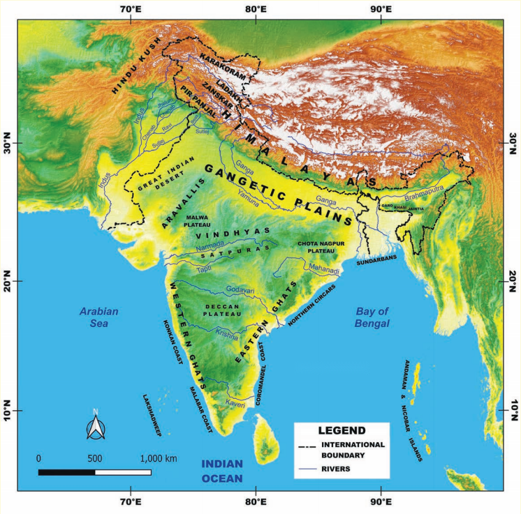
Look at the map of India given below. What are you able to observe? Recall your lesson on different types of landforms—mountains, plains and plateaus. Which landforms can you identify on the map? What do the different colours on the map mean? (Page – 2)

Answer:

Geographical Diversity of India Class 7 Diagram 1

The various types of landforms that I can identify on the map as follows:

The different colours on the map mean:

Question 2


Do you recall your lesson on latitudes and longitudes? Look at the above map. Can you read, approximately, the latitude and longitude where India lies?
Identify the above features on India’s physical map. (Page 3)
Answer:

Question 3

Can you loca te the names of the states in the different parts of the Himalayas? Take the help of both the physical and political maps for this exercise. (Page 6)
Answer:
The Himalayan region is divided into three main parts:

Western Himalayas – Found in the states of:

Central Himalayas – Found mainly in:

Eastern Himalayas – Found in:

Question 4


Notice the concentration of lightning in the plains. What could be the reason for this concentration? (Page 11
Answer:
The concentration of lightning in the plains can be attributed to several factors:

Question 5


What is the shape of a sand dune? While mountains are made of rock and their shape is fixed, why do you think sand dunes also have a similar shape, even though they are made of sand? (Page 12)
Answer:
A sand dune usually has a crescent or ridge-like shape, with one side gently sloping and the other side steeper. Although sand dunes are made of loose sand and not solid rock like mountains, they often maintain a similar shape because of the consistent direction of wind. Wind carries sand particles and deposits them in a particular pattern, forming a dune. As long as the wind blows in the same direction, the shape of the dune remains stable. Even though the material is loose, the forces of nature especially wind direction and speed keep reshaping the sand in such a way that dunes retain a recognizable form, just like mountains maintain theirs due to the solid structure of rocks.

Question 6


Let’s go back to the map (given on page 8). Trace your path slowly from the Thar Desert towards the east. Do you see the Aravalli Hills? (Page 14)
Answer:
Yes, when we trace the path from the Thar Desert towards the east on the physical map of India, we can see the Aravalli Hills.
The Aravalli Hills are located in the eastern part of the Thar Desert, mainly in the state of Rajasthan. They appear as a narrow hill range running in a southwest to northeast direction. These hills are one of the oldest fold mountain ranges in India and act as a natural boundary, partly separating the desert from the more fertile plains to the east.

Question 7


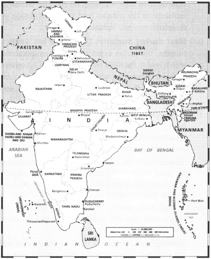
Look at the political map given below and identify the states that the range spans. Did you see Delhi, Rajasthan, Haryana and Gujarat? (Page 15)

Answer:
Yes, the Aravalli Range spans across the following states in the political map of India:

Geographical Diversity of India Class 7 Diagram 2

Question 8


Look at the physical map of India (given on page 8) of the book. Notice the direction of the flow of the rivers. (Page 16)
Answer:
We can see the following directions of river flow:

Question 9


Tribal communities are largely spread over the states of Jharkhand, West Bengal, Odisha, Assam, Madhya Pradesh, Chhattisgarh, Maharashtra, Telangana, and Gujarat. Examine the physical map (on page 8) and political maps given above to locate the states and connect them to their location on the physical map. (Page 17)
Answer:
We can observe the following:

Question 10


Look at the physical map of India in your school atlas or wall map and find the names of five rivers that flow into the Bay of Bengal. Find out India’s coastal states and discuss the difference between the western and eastern coastal plains. (Page 19)
Answer:

Five rivers that flow into the Bay of Bengal are:

India has the following coastal states: Eastern Coastal States (along the Bay of Bengal):

Western Coastal States (along the Arabian Sea):

The difference between the western and eastern coastal plains are as follows.

Feature

Western Coastal Plains

Eastern Coastal Plains

Location

Between Western Ghats and Arabian Sea

Between Eastern Ghats and Bay of Bengal

Width

Narrow (50 to 100 km)

Wide (up to 120 km)

Rivers

Small rivers, e.g., Narmada, Tapi

Large rivers with deltas, e.g., Godavari, Mahanadi and Ganga

Terrain

Rocky and uneven

Flat and fertile

Coastal Features

Features estuaries and lagoons backwaters (e.g., Kerala)

Large deltas and lagoons

Question 11


Do you know what it is called when these rivers split into multiple streams near the coast? Discuss with your teacher in class to find out!
Answer:
Yes, when rivers split into multiple streams near the coast, especially before entering a sea, it is called a delta. This process is called “delta formation”, and the streams are called distributaries. For example, the Ganga-Brahmaputra and Godavari rivers form large deltas.

Class 7 SST Chapter 1 Geographical Diversity of India Question Answer (Exercise)

Question 1


What, in your opinion, are two important geographical features of India? Why do you think they are important?
Answer:
Two important geographical features of India are the Himalayas and the Northern Plains. The Himalayas protect India from cold winds from the Central Asia and also bring rainfall by blocking the monsoon winds. The Northern Plains are very fertile due to the rivers like the Ganga, making it suitable for agriculture and supporting a large population.

Question 2


What do you think India might have looked like if the Himalayas did not exist? Write a short note or sketch a drawing to express your imagination.
Answer:
If the Himalayas did not exist, India might have been a dry and cold region like Central Asia. The monsoon winds would not have been trapped, resulting in less rainfall. There would have been more deserts and fewer rivers, and farming would have been difficult. The
northern region would not be as populated as it is today.

Question 3


India has been called a ‘mini-continent’. Based on what you’ve read, why do you think this is so?
Answer:
India is called a ‘mini-continent’ because of its vast size and varied geographical features. It has mountains in the north, deserts in the west, fertile plains, plateaus in the south, and long coastlines. It also has a great diversity of climates, languages, cultures, and traditions, making it feel like a continent within a country.

Question 4


Follow one of India’s big rivers from where it starts to where it meets the ocean. What are the different ways in which people might utilise this river along its journey?
Answer:
Let’s take the Ganga River. It starts from the Gangotri Glacier in the Himalayas and flows through Uttarakhand, Uttar Pradesh, Bihar, and West Bengal before emptying into the Bay of Bengal. Along its journey, people use the river for drinking water, farming (irrigation), bathing, religious rituals, fishing, and transportation.

Question 5


Why is the southern part of India referred to as a peninsular plateau?
Answer:
The southern part of India is called a peninsular plateau because it is a raised landmass that is surrounded by water on three sides the Arabian Sea, the Bay of Bengal, and the Indian Ocean. It is made of hard rocks and is older than the northern plains, with hills, rivers, and valleys.

Question 6


Which UNESCO Heritage Site mentioned in this chapter did you find more interesting? Write a short paragraph to describe what about it is interesting.
Answer:
I found the Western Ghats very interesting. They are a UNESCO World Heritage Site because they are one of the world’s eight “hottest hotspots” of biological diversity. They have many types of plants and animals that are not found anywhere else. They are also very important for controlling climate and rainfall in the region.

Question 7


Look at the two maps of India, physical as well as political (given on page 8 and page 10 respectively). Identify the place you are at now. Which physical feature of India would you use to describe its location?
Answer:
I am in Delhi, which is located in the Northern Plains of India. This area is flat and fertile because of rivers like the Yamuna and the Ganga. It is part of the Indo-Gangetic plains, which are good for agriculture and densely populated.

Question 8


Food preservation techniques differ from place to place across India. They are adapted to local conditions. Do a class project. Gather different methods of preserving food.
Hint: Drying vegetables when they are in season for use during the off-season.
Answer:
Do it yourself.

Question 9


Despite having such different regions (mountains, deserts, plains, coasts), India remains one country. How do you think our geography has helped unite people?
Answer:
India’s geography has helped people to connect and depend on each other. Rivers from the mountains bring water to the plains, while crops grown in the plains are shared with hilly and desert areas. Coastal areas help with trade and travel. Over time, people from different regions have shared ideas, food, festivals, and traditions, helping to unite India as one nation.

In-Article Ad Slot

CBSE 2026-27 Board Exam Preparation & Practice Papers

Free Chapter Notes & Question Bank by BoardExams.in